Coral Sea

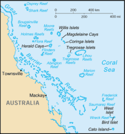
The Coral Sea is a marginal sea off the north-east coast of Australia. It is bounded in the west by the east coast of Queensland, thereby including the Great Barrier Reef, in the east by Vanuatu (formerly the New Hebrides) and by New Caledonia, and in the north approximately by the southern extremity of the Solomon Islands.[1] South of it is the Tasman Sea.
The Coral Sea Basin was formed between 58 million - 48 million years ago when the Queensland continental shelf was uplifted, forming the Great Dividing Range, and continental blocks subsided at the same time.[2] The sea is ecologically an important source of coral for the Great Barrier Reef, both during its formation and after sea level lowering.[3]
The sea was the location for the Battle of the Coral Sea, major confrontation during World War II between the navies of the Empire of Japan, and the United States and Australia.
Contents |
Extent
While the Great Barrier Reef with its islands and cays belong to Queensland, most reefs and islets east of it are part of the Coral Sea Islands Territory. In addition, some islands west of and belonging to New Caledonia are also part of the Coral Sea Islands in a geographical sense, such as the Chesterfield Islands and Bellona Reefs.
The International Hydrographic Organization defines the limits of the Coral Sea as follows:[4]
On the North. The South coast of New Guinea from the entrance to the Bensbak River (141°01'E) to Gado-Gadoa Island near its Southeastern extreme (), down this meridian to the 100 fathom line and thence along the Southern edges of Uluma (Suckling) Reef and those extending to the Eastward as far as the Southeast point of Lawik Reef () off Tagula Island [Vanatinai], thence a line to the Southern extreme of Rennell Island and from its Eastern point to Cape Surville, the Eastern extreme of San Cristobal Island [Makira], Solomons; thence through Nupani, the Northwestern of the Santa Cruz Islands () to the Northernmost Island of the Duff or Wilson Group ().
On the Northeast. From the Northernmost island of the Duff or Wilson Group through these islands to their Southeastern extreme, thence a line to Mera Lava, New Hebrides Islands [Vanuatu] () and down the Eastern coasts of the islands of this Group to Aneityum Island () in such a way that all the islands of these Groups, and the straits separating them, are included in the Coral Sea.
On the Southeast. A line from the Southeastern extreme of Aneityum Island to Southeast (Nokanhui) Islets () off the Southeast extreme of New Caledonia, thence through the East point of Middleton Reef to the Eastern extreme of Elizabeth Reef () and down this meridian to Latitude 30° South.
On the South. The parallel of 30° South to the Australian Coast.
On the West. The Eastern limit of the Arafura Sea [The entrance to the Bensbak River (141°01'E), and thence a line to the Northwest extreme of York Peninsula, Australia ()] and the East Coast of Australia as far South as Latitude 30° South.
Tourism
The Coral Sea is also a dive tourism destination. Its spectacular wall dives and large pelagic species making it a popular dive destination. This is especially because of the famous Great Barrier Reef.
See also
- USS Coral Sea (aircraft carrier)
- Coral Sea Islands
References
Notes
- ↑ http://permanent.access.gpo.gov/websites/pollux/pollux.nss.nima.mil/NAV_PUBS/SD/pub127/127sec06.pdf>
- ↑ Hopley, David; Smithers, Scott G.; Parnell, Kevin E. (2007). The geomorphology of the Great Barrier Reef : development, diversity, and change. Cambridge : Cambridge University Press. p. 19. ISBN 0521853028.
- ↑ Hopley, David; Smithers, Scott G.; Parnell, Kevin E. (2007). The geomorphology of the Great Barrier Reef : development, diversity, and change. Cambridge : Cambridge University Press. p. 27. ISBN 0521853028.
- ↑ "Limits of Oceans and Seas, 3rd edition". International Hydrographic Organization. 1953. http://www.iho-ohi.net/iho_pubs/standard/S-23/S23_1953.pdf. Retrieved 7 February 2010.
Further reading
- Bradley, Claire (2009-01-18). "Catch and Release". Sunday Herald Sun (News Limited): pp. Sunday magazine supplement (pp. 19–20). http://www.pressdisplay.com/pressdisplay/viewer.aspx?issue=18132009011800000000001001&page=19&article=6938c434-0f17-4550-9284-43a0abb8f467&key=THB9a8/QLRTlsUxg6JzIow==&feed=rss.—article on 2009 documentary, Mysteries of the Shark Coast, part of a "greater plan to extend the boundaries of the Great Barrier Reef to the Coral Sea [the Osprey Reef] and, in turn, protect the [grey reef and whitetip] sharks that call this region home."
- Australian Underwater Federation. "Community monitoring of reef sharks in the Coral Sea and Great Barrier Reef, Australia" (2008)
External links
 Media related to Coral Sea at Wikimedia Commons
|
||||||||||||||||||||